Project Context
Arcadis, acting on behalf of Crestar Management Ltd. and Bahari Investments Ltd., hereby submits a land use amendment and outline plan application for a parcel of land located in Harvest Hills, in northeast Calgary. The site spans approximately ±5.48 hectares (±13.54 acres) and is bordered by the CP Rail line to the east, existing single-family residential areas to the west, and 96 Avenue NW to the south.
The subject site's municipal address is 10220 6th Street NE, legally identified as a portion of SW23-25-1-5. The site is privately owned and currently zoned as Special Purpose - Future Urban Development (S-FUD) which is a holding district for lands earmarked for comprehensive future development initiatives.
Proposed Plan
The subject site is being comprehensively planned to facilitate a thoughtfully integrated low to modest density residential enclave.
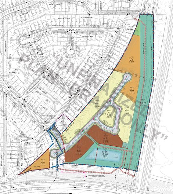
Proposed land uses include:
- Residential - Low-Density Mixed Housing (R-G) – Single detached homes and townhomes;
- Multi Residential - (M-G) – Rowhomes and Townhomes;
- Multi Residential - (M-H1 f2.5h22) – 4 to 6 Storey Apartment buildings;
- Special Purpose – School, Park, and Community Reserve (S-SPR) to augment existing Park and trails; and
- City and Regional Infrastructure (S-CRI) to accommodate enhanced stormwater management infrastructure and formalize informal trail systems.
Outline Plan and Development Vision
The plan aims to integrate sensitively with the existing residential fabric, offering a variety of low density housing options like single detached homes, duplexes and townhouses directly adjacent to the existing single-family homes west of the site. Building form will transition from single-family houses to duplexes and townhouses and step gradually up to medium density housing types, such as multi-family apartment style residences along the proposed storm pond located internal to the site at the south end. Unique, custom designed townhomes will be considered within a number of irregularly shaped parcels to take advantage of their unique lot configurations.
The location of Special Purpose - School, Park, and Recreation area (S-SPR) is intended to increase the quality of the current municipal reserve land at the north end of the property and framed with multi-residential (M-G) housing adjacent to it.
The Special Purpose District (S-CRI) is intended to leverage the existing storm water retention area at the southeast corner of the property to facilitate a larger more naturalized storm pond to enhance stormwater management infrastructure as well as contribute to the naturalized open space network.
This submission aims to unlock the site's potential for future development while contributing to the cohesive growth of Harvest Hills and its surrounding areas, while helping to supply much needed new housing in Calgary.
The anticipated maximum number of new homes is 182 equating to approximately 12.35 units per acre which is similar to most new greenfield development area across the City.
Governing Policy
Aligned with the City of Calgary's Municipal Development Plan, the proposal seeks balanced growth and strategic development within established and serviced areas. This parcel is currently designated as an Employment District in the Calgary North Phase 1 Area Structure Plan, which was largely attributed to the nature of Calgary's International Airport's NEF (Noise Exposure Forecast) Contours that restricted residential uses. Therefore, the site is currently structured to accommodate employment uses such as office, light industrial and commercial.
However, the NEF Contours have since been updated and no longer poses the residential constraints. Therefore, this presents an opportunity to update the Calgary North Phase 1 ASP. The updates to air traffic noise supports a minor amendment to the Area Structure Plan (ASP) to accommodate residential uses instead of employment uses and is one of the key attributes of this proposal.

Noise Exposure Forecast Protection Area
As noted above, with the update of the Noise Exposure Forecast (NEF) contours in August 2021, the subject land is no longer within the 30-35 Noise Exposure Forecast protection area and can now accommodate residential uses which potentially presents a better use integration with the existing community to the west which is predominantly residential in nature.

Open Space Network
The proposed plan aims to enhance pedestrian access and connectivity within the site and its neighbouring northwest areas, as well as add new regional pathways that offer connections to the existing regional pathway systems located along the north and south portion of the site.
Local connections will be integrated into the site, which includes amenities such as sidewalks and multi-use pathways within the proposed road right of ways and recreational trails/pathways that are integrated within the proposed S-CRI designated areas and dedicated as public land to eliminate the current trespassing situation. Altogether, this will provide seamless connectivity throughout the site, enhancing accessibility and usability for residents and visitors. Additionally, it will contribute to the overall enhancement of the eastern portion of the site, creating a cohesive and inviting environment for all. Over 39% of the Outline Plan area will not be developed and will be dedicated to open space systems and green infrastructure.

Transportation and Site Access
The site is framed by 96 Avenue NE on the south, the Canadian Pacific rail line on the east and residential houses that span along the west side. The site currently has no direct access to a public road right-of-way and the City is working collaboratively with the applicant to find an alternative access solution. This proposal seeks to introduce a new primary access along the existing utility right-of-way that links the site to Harvest Creek Close NE and be a logical extension of Harvest Lake Drive NE. To facilitate this, a small portion of an MR parcel will need to be transitioned to a public road right of way to accommodate the new public entry road. This is a safe, reasonable and necessary access solution to the subject parcel in lieu of the limitations created by the changes made by the City to the previous site access from 96th Avenue.
The proposed internal road network is planned to ensure that access within the proposed development and land uses will be sufficient for local and emergency traffic, safe pedestrian movement and servicing. Given the relatively modest intensity of the proposed development, the existing and future road network is anticipated to have sufficient capacity to maintain a safe and acceptable level of service.